In the high-precision positioning industry, CORS networks have long handled surveying, engineering, public services, and more. GEODNET, however, represents a new DePIN-powered approach to real-world infrastructure. Understanding what sets them apart helps build a clearer mental model for high-precision positioning.
What Is GEODNET?
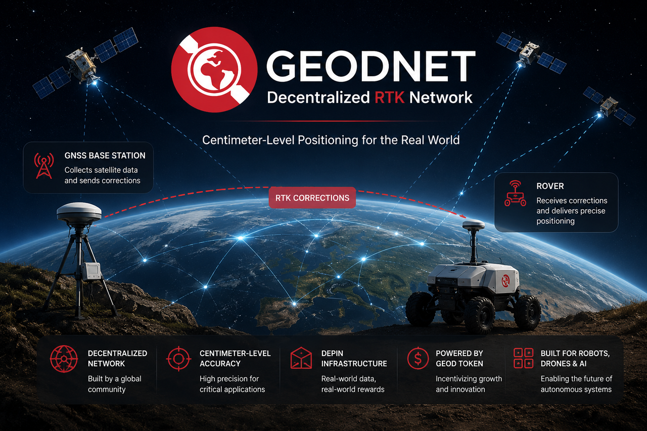
GEODNET is a global high-precision positioning network built on DePIN (Decentralized Physical Infrastructure Network). It rewards users who deploy GNSS reference stations and provide RTK correction data for drones, robots, autonomous driving systems, and surveying equipment. Node operators earn GEOD tokens by contributing to the network's positioning infrastructure.
Compared with traditional positioning service networks, GEODNET stands out for its open participation model and community-driven growth—any qualifying node can join and share data.
What Is a Traditional CORS Network?
CORS (Continuously Operating Reference Station) networks are among the most common RTK infrastructure types. They consist of many fixed GNSS reference stations that continuously monitor satellite signals to generate error corrections, supporting surveying, engineering, and high-precision navigation. Most CORS networks are built and managed by government agencies, surveying departments, or commercial operators, typically covering specific countries, regions, or cities.
Unlike open networks, traditional CORS networks generally follow a centralized model: unified construction, unified maintenance, and unified billing.
How Do Their Construction Models Differ?
The construction model is one of the biggest differences between GEODNET and CORS networks.
Traditional CORS networks rely on government funding or commercial entities to build reference stations—each site requiring professional selection, equipment procurement, and long-term maintenance. GEODNET, by contrast, uses a community-driven model. Node operators deploy their own compliant GNSS reference stations and connect them to the network to share data.
This approach spreads infrastructure costs across global participants instead of placing them on a single organization, lowering the barriers to expansion.
How Do Their Operational Structures Differ?
CORS Networks Operate Centrally
Traditional CORS networks are typically run by a single administrative body. All network planning, equipment purchasing, station maintenance, and data management are handled centrally. This ensures consistent standards and uniform service quality.
GEODNET Operates in a Decentralized Manner
GEODNET’s reference stations are run independently by community members worldwide. The network coordinates nodes through protocol rules and incentives rather than through a centralized authority. This increases openness and participation.
How Do They Expand Coverage?
Coverage defines the service area of any high-precision positioning network.
Expanding a traditional CORS network usually means building new reference stations, which involves lengthy planning, approval, and deployment cycles—limiting growth speed.
GEODNET attracts global users to deploy nodes using token incentives. As long as demand exists in a region, new stations can be quickly added. So in theory, GEODNET can expand globally much faster.
How Do Their Economic Models Differ?
The economic model determines the long-term momentum of the network.
CORS Network Revenue Sources
Traditional CORS networks generate income through:
- Government funding
- Surveying project budgets
- Enterprise subscription services
- Fees for professional positioning solutions
GEODNET’s Incentive Mechanism
GEODNET has built a token economy driven by supply and demand:
- Node operators earn GEOD rewards
- Enterprises and developers pay for positioning services
- Growing demand directly fuels infrastructure expansion
This creates a direct link between network growth and real market need.
How Does Data Quality Compare?
Data quality is the core of any high-precision positioning service.
Traditional CORS networks—built and maintained under unified standards—tend to have strong data consistency and controllability. GEODNET, with its more diverse node sources, relies on automated monitoring, data scoring, and network rules to maintain overall quality. As the node count grows, quality control becomes increasingly important. The two models take different paths to achieve reliable data.
Which Scenarios Fit GEODNET Best?
GEODNET is ideal for applications needing global coverage and fast scaling.
Autonomous Driving
Cross-region autonomous driving systems need wide positioning coverage.
Robotics
Robots deployed across different countries and cities benefit from global infrastructure.
Drone Networks
Drone operators expect consistent services across multiple regions.
Physical AI
Real-world AI systems require continuous, accurate spatial data.
GEODNET’s open architecture can better meet these needs.
Which Scenarios Fit Traditional CORS Networks Best?
Traditional CORS networks still excel in certain professional scenarios.
Government Surveying Projects
National surveying systems require unified management and long-term stability.
Engineering Construction
Large projects demand high data standardization.
Public Service Systems
Public infrastructure often relies on long-stable operating institutions.
Regional Professional Positioning
Fixed-area high-precision positioning remains a key CORS use case.
GEODNET vs. Traditional CORS Network
| Dimension |
GEODNET |
Traditional CORS Network |
| Network Architecture |
Decentralized |
Centralized |
| Station Building |
Community-deployed |
Government or enterprise-built |
| Coverage |
Global |
Regional |
| Expansion Speed |
Fast |
Slow |
| Incentive Mechanism |
GEOD token rewards |
No open incentive |
| Data Management |
Protocol-based governance |
Centralized management |
| Participation Barrier |
Open to all |
Institution-led |
| Typical Uses |
Robotics, autonomous driving, drones |
Surveying, engineering, public services |
Summary
Both GEODNET and traditional CORS networks are based on GNSS and RTK technology and can provide centimeter-level high-precision positioning. Their main difference isn’t the positioning principle itself, but how the infrastructure is built and operated.
Traditional CORS networks use a centralized model, with proven experience in regional surveying and public services. GEODNET, through DePIN, introduces community participation and token incentives, allowing high-precision positioning to expand in a more open, global way. As robotics, autonomous driving, and Physical AI grow, both models are likely to coexist, serving different positioning needs.
FAQs
What Is a CORS Network?
A CORS (Continuously Operating Reference Station) network is a high-precision positioning infrastructure made of fixed GNSS reference stations, delivering centimeter-level accuracy via RTK correction data.
Is GEODNET a CORS Network?
Both GEODNET and CORS networks offer RTK services, but GEODNET uses a decentralized construction model, so it's generally classified as a DePIN high-precision positioning network, not a traditional CORS network.
Which Has Higher Positioning Accuracy: GEODNET or CORS?
Both rely on RTK technology. When coverage and data quality requirements are satisfied, both can achieve centimeter-level accuracy. Actual performance depends more on station density and network conditions.
Why Does GEODNET Use Token Incentives?
GEODNET uses GEOD tokens to motivate global users to deploy reference stations, accelerating network expansion and reducing traditional infrastructure costs.
What Are the Advantages of Traditional CORS Networks?
Traditional CORS networks offer unified management, standardized construction, and long-term stable operations, making them widely used in surveying and engineering.
Will GEODNET Replace Traditional CORS Networks?
GEODNET is more likely to complement traditional CORS networks. The two models serve different needs and are expected to coexist and evolve together over time.